
SOUTH AMERICA
South America is the fourth-largest continent, covering 17,8 million square kilometres, and is home to over 430 million people. It features some of the planet’s most striking extremes: the Amazon rainforest—the largest on Earth—covering over 5.5 million square kilometres (half the size of all Europe) and the Andes, the world’s longest mountain range, stretching over 7,000 kilometres along the continent's western edge.
-
South America also hosts the driest non-polar desert, the Atacama, where parts receive an average rainfall of as low as 5 millimetres per year. The vast Pantanal is the largest tropical wetland, covering over 150,000 square kilometres in Brazil, Bolivia, and Paraguay. It supports diverse wildlife, including jaguars, capybaras, caimans, and hundreds of bird species.
The Amazon is the world’s largest tropical rainforest, spanning nine South American countries (Brazil, Peru, Colombia, Venezuela, Ecuador, Bolivia, Guayana, Suriname and French Guayana). It is a biodiversity hotspot, home to an estimated 10% of the planet's known species. The Amazon River, one of the longest in the world, runs through the forest, sustaining countless aquatic and terrestrial ecosystems. Amazon plays a crucial role in regulating the Earth's climate, acting as a carbon sink and producing about 20% of the world's oxygen. Despite its importance, the Amazon faces significant threats from deforestation, mining, and climate change.
Andes are one of the greatest natural features on Earth, stretching across the South American continent from the northern Caribbean coast of Colombia and Venezuela to its southern tip in Chilean Patagonia. This vast mountain range is composed of high plateaus and towering peaks that separate the narrow western coastal strip from the rest of the continent, influencing the climate and the ecosystems within the range, as well as the surrounding areas. In the Northern Andes (Colombia, Ecuador, and northern Peru), the mountains feature volcanic activity, and substantial rainfall that supports tropical rainforests, cloud forests, and high-altitude páramos. Central Andes (Peru, Bolivia, northern Chile and Argentina) are dominated by high-altitude plateaus, deserts, glacial valleys, and volcanic peaks. This area is geologically complex, with both active volcanoes and ancient tectonic activity shaping the landscape. In the Southern Andes (Chile and Argentina), the terrain and mountains become more fragmented with dramatic glacial fjords, volcanic systems, and vast steppe regions.Indigenous communities, such as the Wayuu, Quechua, Aymara, Mapuche, and many others, have long considered the Andes to be sacred. For them, mountains are not only a source of life and culture but part of their identity.

Colombia, with its diverse habitats and rich biodiversity, is home to an impressive variety of hummingbirds, showcasing some of the world's highest concentrations and most colourful species. (Sierra Nevada de Santa Marta, Colombia)

The Sierra Nevada de Santa Marta, separated from the Andes, is the highest coastal mountain range in the world, with Pico Cristóbal Colón reaching up to 5,775 meters. It is home to several indigenous communities such as the Kogi, Arhuaco, and Wiwa, who consider the mountains the centre of the world. They view the region as a spiritual and cosmological heart, connecting the physical and spiritual realms. (Sierra Nevada de Santa Marta, Colombia)

Páramo is a diverse ecosystem, endemic only to the northern Andes of South America and the southern part of Central America. It is perhaps the fastest evolving biodiversity hotspot on Earth, as species evolved within a diversified landscape of glacier-formed valleys and plains with lakes, and wet grasslands scattered with shrubland and forest patches. (Los Nevados, Colombia)

Frailejones or espeletia are endemic plants only found in the páramo ecosystem. They contribute to water sustainability by capturing water vapour in their spongy trunk from passing clouds and releasing it into the soil through their roots. Through that, they create important lakes and other high-altitude subterranean water deposits that eventually form rivers. (Los Nevados, Colombia)

In Colombia, campesinos or farmers lead a lifestyle rooted in traditional agriculture and a close relationship with the land. Many grow crops like coffee, sugarcane, and corn on small family farms. Their life is centred around community, self-sufficiency, and respect for the land. (Cauca, Colombia)

Macizo Colombiano is a geographical and ecological region in southern Colombia within Cauca, Huila, and Nariño. It is the source of many of Colombia’s most important rivers, including the Magdalena, Cauca, Patía, and Caquetá rivers, earning it the title "the water factory of Colombia." (Huila, Colombia)

Located near the equator, Cotopaxi's glacier begins at around 5,000 m.a.s.l., defying the expectations of tropical climates. Tropical glaciers are highly sensitive to climate change, with accelerated melting threatening water resources and increasing hazards such as volcanic mudflows (lahars). (Cotopaxi, Ecuador)

Huayhuash is the second-highest Peruvian mountain range, close to the city of Huaraz, an eight-hour bus ride north of Lima. In just 30km, it holds seven peaks over 6000m neighboured by lesser peaks, glaciers, high-mountain passes, narrow valleys and multiple colour lakes. (Huayhuash, Peru)

Views towards Laguna Mitococha and surrounding valleys. The Circuito Alpino, a higher-altitude route in the Huayhuash mountain range, offers closer proximity to the peaks, stunning vistas, and occasional glacier crossings. (Huayhuash, Peru)

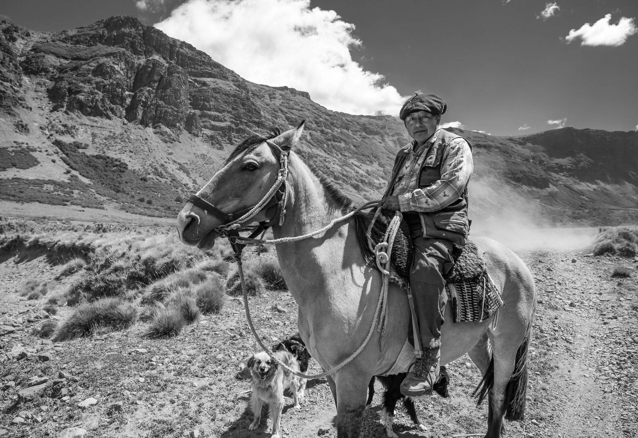
Mules are the main means of transport in remote mountains of South America, where rugged terrains and steep paths make vehicles impractical. Strong and resilient nature of mules makes them well-suited to harsh conditions, including high altitudes and extreme weather. (Huayhuash, Peru)

The Cordillera Huayhuash remained unprotected until 2002 when the Peruvian government declared it a "Reserved Area." Today, the local communities surrounding the range, including Llámac, Queropalca, Huayllapa, and Pacllon, have become key custodians of these lands. (Huayhuash, Peru)

"Huayhuash" comes from the Quechua term which refers to a type of Andean weasel found in the region. It is also known as "mashallu" in Quechua. (Huayhuash, Peru)

Perched high in Peru's Andes Mountains, Machu Picchu is a stunning 15th-century Inca city that reveals the civilization’s remarkable skills in engineering, architecture, and harmonious integration with nature. (Cusco, Peru)

Quechua, an indigenous group primarily residing in the Andean highlands of South America, have a rich cultural heritage rooted in the legacy of the Inca Empire. Spanning several countries, including Peru, Bolivia, Ecuador, and Colombia, they preserve their traditions, unique language, agricultural practices, and social customs. (Cusco, Peru)

Quechua communities endure extreme weather above 4,500 meters, relying on alpacas and llamas for meat, fleece, and economic sustenance. (Ausangate, Peru)

Llama is a domesticated South American animal primarily found in the Andes, where it has been used for centuries by indigenous people as a pack animal, valued for its strength, wool, and meat. (Cusco, Peru)

Salkantay, which means "Savage Mountain" in Quechua, is considered an apu or sacred peak as holds deep spiritual significance. (Cusco, Peru)

The Hoatzin bird is often called the "stinkbird" due to its strong odour, which comes from its unusual digestive system, which ferments vegetation in its crop, similar to how cows digest food. Additionally, young Hoatzins have claws on their wings, a primitive trait that harks back to the age of dinosaurs, allowing them to climb trees before they can fly. (RN Tambopata, Peru)

Caymans belong to the alligator family and are native to Central and South America. They inhabit freshwater environments like rivers, lakes, and swamps. (RN Tambopata, Peru)

Kinsa Cocha are three beautiful lakes at about 4,000m in the Sacred Valley region near Cusco. "Kinsa" means "three" in the Quechua language and "Cocha" means "lake". (Cusco, Peru)

Known for their traditional healing practices, the Kallawaya are highly regarded as herbalists, with knowledge of medicinal plants passed down through generations. Their ancient system of healing, which blends plant-based remedies and spiritual beliefs, has been recognized by UNESCO as part of the world's cultural heritage. (Curva, Bolivia)

Communities of the Cordillera Apolobamba, mostly Aymara and Quechua rely on families working together, herding alpaca and llamas and terrace farming to grow crops like potatoes and quinoa. Family structures are central to their social organization passing down oral traditions and ancestral knowledge. (Caalaya, Bolivia)

Isla del Sol on Lake Titicaca in Bolivia, on 3809 m.a.s.l. the highest navigable lake in the world and the largest freshwater lake in South America. The island derives its name from the Temple of the Sun, a sacred site where, according to Inca mythology, the sun god sent Manco Cápac and Mama Ocllo, the legendary founders of the Inca dynasty, to the Earth. (Isla del Sol, Bolivia)

For the Aymara and Quechua people, the apus are sacred mountains considered the earthly embodiments of powerful deities, believed to protect the people living in their shadow. These mountains are deeply connected to Pacha Mama, the Andean goddess of the earth, fertility, and agriculture, representing the natural cycles and the life-giving sustenance that the earth provides. (Sorata, Bolivia)

The snow-capped summit of Huayna Potosí, called Qaqaqa Achachila in Aymara, meaning "the youngest grandfather," "supreme judge," and "sovereign natural temple," holds great cultural significance as one of the region’s prominent deities. (Pico Austria, Bolivia)

Cordillera Real in La Paz is a major mountain system stretching over 120 km from the mountains Illampu on the north to Ilimani on the south, separating the Amazon basin's lowlands from the high-altitude Altiplano plateau. (Pico Austria, Bolivia)

With 6,088 meters and easy accessibility to climbers, Huayna Potosi is attracting both experienced mountaineers and beginners seeking to summit a major Andean peak. (Huayna Potosi, Bolivia)

Tropical glaciers, like those on Huayna Potosí, are rapidly melting due to rising temperatures. Their ice is thinner and more sensitive to temperature changes than polar glaciers, making them highly vulnerable to global warming. As they melt, these glaciers reduce water availability, impacting agriculture, local livelihoods, and the biodiversity of mountain ecosystems. (Huayna Potosi, Bolivia)

In 2019 five Indigenous Aymara women, known as the Cholitas Escaladoras, climbed Aconcagua—the highest mountain outside of Asia at 6,962 meters. They climbed proudly wearing their traditional clothes: bright layered skirts (polleras), woollen bags (aguayos), and braided hair. (Huayna Potosi, Bolivia)

With their charm, strength, and determination to climb the mightiest mountains, Cholitas Escaladoras bring honour to the word "cholita," which less than ten years ago was still used as a racial slur. They are an inspiration to women in Bolivia and around the world. (Huayna Potosi, Bolivia)

Lita started climbing when she was only 12 years old. Energetic and strong-willed, she has higher goals—such as climbing 8,000-meter mountains in the Himalayas. (Huayna Potosi, Bolivia)

Illimani, towering over La Paz at 6,438 meters, is not only the highest peak of the Cordillera Real but also considered a guardian spirit viewed as a protector of the city and its people. (La Paz, Bolivia)

Valle de las Ánimas in Bolivia was shaped by centuries of erosion of soft sandstone, creating towering, jagged rock spires that make up its dramatic, otherworldly landscape. (La Paz, Bolivia)

The El Tatio Geyser Field, located in northern Chile at 4,320 meters above sea level, is the third largest geyser field in the world and the largest in the Southern Hemisphere. (Atacama Desert, Chile)

James's and Andean flamingos at Laguna Colorada, Bolivia. Their pink colour is the result of the diet of beta-carotene-rich algae. Laguna Colorada is one of the most important feeding sites, with up to 40,000 individuals. (Atacama Desert, Bolivia)

Atacama shared by Chile, Bolivia, Peru and Argentina is the driest non-polar desert in the world. Its extreme aridity is caused by a combination of factors, including its location in the rain shadow of the Andes Mountains and the cold Humboldt Current offshore. (Atacama Desert, Chile)

Despite its inhospitable climate, the Atacama is home to unique ecosystems, including salt flats, dunes, high-altitude lagoons and a variety of specialized flora and fauna that have adapted to the harsh conditions. (Atacama, Chile)

Found at elevations of up to 5,000m, vicuñas, a wild relatives of llama, are specially adapted to the harsh, cold, and dry conditions of the Atacama, where they graze on grasses and other vegetation. Due to historical overhunting, their populations were severely reduced, but conservation efforts have helped them recover in recent years. (Atacama Desert, Chile)

Due to its high altitude, dry climate, and lack of cloud cover Atacama Desert is one of the best places in the world for stargazing and astronomical observation. The region contains several world-renowned observatories - ALMA (Atacama Large Millimeter/submillimeter Array) and the Paranal Observatory. (Atacama Desert, Chile)

South of Santiago de Chile the Andes are represented by the ancient volcanos characterized by sand erosion, creating moonlike landscapes. (Maule, Chile)

Sand erosion contrasts with the existence of oases which are typically formed where underground water sources emerge, offering a vital supply of water in an otherwise desolate region. This supports unique plant and animal species, adapted to survive in the otherwise dry, sandy environment. (Maule, Chile)

Araucaria, or pehuén, is a coniferous species that dates back to the time of the dinosaurs. Their seeds, known as piñones, are rich in carbohydrates and have been a staple food for native Pehuenche communities. (Araucania region, Chile)

Araucanía region is characterized by the iconic araucaria or pehuén trees. These conifers, dating back over 240 million years, are among the most distinctive flora of the region. (Araucania region, Chile)
Señor Segundo, a friendly campesino, and his wife own a small farm deep in the Patagonian wilderness. (Araucania region, Chile)

Shelter of a welcoming local family which herds sheep and goats around the fertile pastures and calls this place home from November to March. (Araucarnia region, Chile)

Villarica is part of the Southern Volcanic Zone, characterized by intense seismic and volcanic activity. It sits along the Pacific Ring of Fire, where tectonic plate movements contribute to continuous eruptions and geothermal activity. (Pucon, Chile)

Cerro Castillo and the surrounding mountains are primarily composed of granite, which formed from ancient tectonic plate movements. The harsh weather conditions, including high winds, rainfall, and freezing temperatures, have shaped the striking granite spires so iconic to Patagonia. (PN Cerro Castillo,

Magnificent Torres de Avellano, shrouded in thick clouds. These rocky towers remain relatively unknown, barely climbed, yet they rival the world-famous mountains Torres del Paine and Fitz Roy further south. (Torres de Avellano, Chile)

Lake General Carrera (or Lake Buenos Aires) is a glacial lake on the border with Argentina. Covering 1,850 km², it is the largest lake in Chile. Its original name, Chelenko, in the local Aonikenk language, means 'stormy waters,' which might explain the strong winds and waves that frequently disrupt the ferry connection between Puerto Ibañez and Chile Chico. (Lake General Carrera, Chile)

Parque Nacional Patagonia, a recently established national park, is rich in diversity, featuring steppes, forests, rocky mountains, and colourful lakes. It is home to several iconic Patagonian animals, including guanacos, pumas, and huemules (shy, rare deer that are the southernmost living species of their kind). (PN Patagonia, Chile)

Before Europeans arrived on the continent, wild populations of guanacos, the largest camelid species in South America, thrived in the millions across Patagonia. Ancestors of the more famous llamas, guanacos are well-adapted to the harsh environment of Patagonia. They can retain and store moisture, have specialized lips, and thick necks that protect them from thorny bushes and predators such as pumas. (PN Patagonia, Chile)

The Magellanic woodpecker is the largest species of its family on the continent. The female has a black head with a distinctive recurved crest, while the male is distinguished by its flame-red head. It digs out grubs from rotting wood with a loud, rapid double-knocking drumming. (PN Patagonia, Chile)

Founded in 1985, El Chaltén is Argentina's youngest town. It has grown dramatically over the past years as a gateway for adventurers, hikers and climbers. (El Chaltén, Argentina)

Fitz Roy, renamed by Perito Moreno during his 1877 expedition is one of the most iconic mountains globally. Originally known as Chaltén, meaning "Smoking Mountain" due to a rare aeolic phenomenon that often cloaks its summit in clouds. (PN Los Glaciares, Argentina)

A tree full of austral parakeets, the southernmost parrots in the world. These vibrant birds are common in the temperate Patagonian forests. (PN Los Glaciares, Argentina)

View over panorama of Cerro Torre, Fitzy Roy, Poincenot, Egger and others. The area gained attention in 1932 when Italian explorer Alberto D'Agostini began documenting the region's geology and landscapes. (PN Los Glaciares, Argentina)

It wasn’t until 1959 that Torres del Paine was officially designated a national park by the Chilean government. This recognition helped protect its unique ecosystems and diverse wildlife. Over time, the park grew in popularity, becoming a global destination for outdoor enthusiasts drawn to its spectacular trekking routes. (Torres del Paine, Chile)

Known for its distinctive appearance, with a bold, large crest and robust beak, the caracara is a scavenger often seen on the ground rather than in flight. It is a bird found throughout Latin America. (Tierra del Fuego, Argentina)
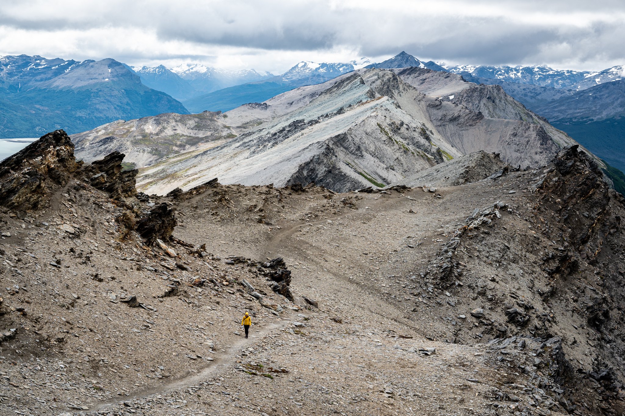
The southernmost part of the Andes, Tierra del Fuego, experiences some of the harshest climates in the world. Strong winds that can exceed 100 km/h, heavy rainfall, and freezing temperatures create a unique geography, ranging from snow-capped peaks to coastal fjords and forests. Nevertheless, it used to be home to several Indigenous groups: the Ona, Yahgan, and Alacaluf. (Tierra del Fuego, Argentina)